By the numbers:
- 237 miles since the last update. From Ocala to Tampa, Florida, around Tampa, and then to the Eastern seaboard and Palm Coast Florida tonight– 4982 miles for the trip.
- One new license plate spotted while in Tampa Bay – CT – only three states left to find.
- 1 National Park today – Canaveral National Seashore. 29 National Parks for the trip to this point. Several more tomorrow.
- 98 degrees with a “real feel” of 105 at the peak of the day.
- 2253 miles – the approximate straight line distance from Seattle to our furthest point from there today at Canaveral Seashore. Less than half the driving distance.
Took a few days to recuperate in Tampa while Peg spent time with a friend who works there. Car service after 5000 miles on the trip and 90,000 for the car revealed no concerns.
Used the time to do anything other than drive. Read some, took a nap, and caught up on some ancestry research. I don’t have any really ancestry from the southern part of the country so nothing particular to explore here regarding that. Just generally keeping up with automated hints from ancestry.com and corresponding with various people with connected family histories. Got one new contact from someone who found me in a DNA research site to which I belong. The DNA indicates we are likely 5th cousins but we have to exchange some info on our family research to try to find which branch of the family that connection might be from. Even with as much research as I have done that type of connecting is not easy. Not long ago I got a similar request from a person born in Vietnam, whose father was an American soldier there during the Vietnam war. He does not know his father’s name but is searching. DNA indicated he and I are likely 5th or 6th cousins. I don’t have information that far out on most of my family tree, and even where I do, I rarely have info on military service. He will need matches with more people who will then have to cross check their trees to find a common line.
Anyway, a bit of a sidetrack from our trip, but that is what I was doing the past few days.
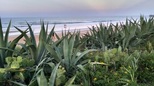
Today, we drove to Canaveral Seashore and then up to Palm Coast, Florida. Always amazing how different each ocean, or gulf or large lake can look. The Atlantic Seashore is so much flatter than anything on the West Coast, the water is much warmer, and the ocean looks more green than does the blue Pacific.  Take that last comment with a grain of salt from a partially color-blind observer. However, my non-color blind, photographer wife agrees with this observation and took this lovely picture:
I wish we could have seen some manatees at Canaveral today but apparently the hot weather this summer has made spotting them much less likely. As with many other stops on this trip we will have to return during cooler weather.
Tomorrow, the plan is for only a short drive, but one filled with several National Park options, on our way up the coast to Jacksonville at the northern shore of Florida. See this map as one of the more interesting tools I have used in planning our trip and trying to see as many parks as possible. After it opens, zoom in on the Florida coast and see how many parks there are between Canaveral and Savannah, Georgia.
http://www.nps.gov/hfc/carto/nps-map-zoomify/nps-wall-map.html