By the numbers:
- 290 miles, from Vicksburg, MS to New Orleans via Natchez– 3920 total miles for the trip.
- highest temp: 93 – Under the idea that it is always good to learn something new every day, we learned something new today. In response to a comment about the heat and being from Seattle at one of the visitor’s centers we were told we shouldn’t mind the heat here because we would be used to the humidity in Seattle. I have lived in a few places with high humidity including Iowa and Washington DC, but until today I did not know Seattle was one of them.
- Traveled through 2 states today: MS and LA, but no new ones.
- License plates for 3 new states today: Rhode Island and Maine. – That leaves just Vermont, New Hampshire, Connecticut, Hawaii, and D.C to spot for the trip.
- Three new national park stamps today for 2 new parks: Melrose Mansion and the William Johnson House at Natchez National Park, and The Natchez Trace Parkway. – 24 total park sites for the trip.
- Elevation number for the day – 11 – more on that below.
The Natchez Trace is another one of those interesting parts of our history about which I knew nothing before. The Trace is now a parkway which runs all the way from Natchez, Mississippi to Nashville, Tennessee.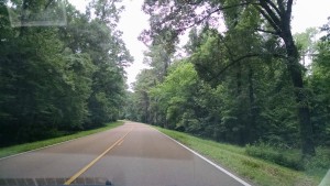 It began as a animal and game path 1000’s of years ago, then became a hunting trail, then a bit of a trading trail, but took a more permanent form in the late 17 and early 18 hundreds. Farmers and traders from the Ohio and upper Mississippi Valley who wanted to sell their goods to people in the more populated Eastern cities would bring their products down the Mississippi on small wooden boat. After selling their goods there was no inexpensive way back up the river. Many sold their boats for the wood and then walked back up to the Ohio Valley. The primary route followed was the Natchez Trace. It took as long as 30 to 40 days to walk that trail and for a time thousands of people made that trek every year.
We are now in New Orleans and will explore the area for the next couple of days. Consider that the main part of the city of New Orleans is at 11 feet elevation. If you have ever been at an ocean beach in even a mild storm, think about how high some of the waves are that come crashing ashore. Then imagine living in a city where the street is lower than the top of some of those waves.
 Here’s my little tidbit of thought related to elevation today. As I have said before, Louisiana is very flat. How flat you ask? Well consider this. Back in Seattle, a few years ago, I redid part of my back yard in the form of a chess board patio. The planning, excavation, building and construction was a fun summer-long project. One thing I learned is that you should never build a patio or driveway perfectly level. If you do, you will have water related problems. The minimum recommended slope for such a project is to have a 1/8th inch rise for every foot of length of you patio. This in necessary to ensure water will run off and not accumulate in puddles in the middle of you patio. Some math:
1/8th inch per foot equals 1 inch per 8 feet which equals 660 inches or 55 feet per mile.
Louisiana is 283 miles long from South to North. So a this same slope would require an elevation of 15,565 feet at the high end.
The highest elevation in the state is actually 535 feet, so Louisiana is 30 times more level than my Chessboard.